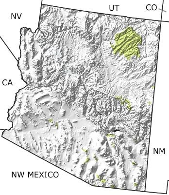
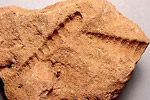
home   Printer friendly version Add to site
Advanced search
Time & Space Fossil Gallery Famous Flora & Fauna
Careers Resources K-12 Collections PaleoPeople

The Cretaceous in Arizona, US

Cretaceous in Arizona map

undifferentiated rock units help

Choose a time period:

Quaternary
Tertiary
Cretaceous
Jurassic
Triassic
Permian
Carboniferous
Devonian
Silurian
Ordovician
Cambrian
Precambrian

Cretaceous Fossils
Fossil photos from Cretaceous in Arizona

Previous (3 slides) Next
Search the fossil gallery

Paleontology and geology

During the Cretaceous Period, southwestern Arizona stood relatively high and continued to dump sediment into low-lying areas to the east. Tectonic activity near the present-day Rocky Mountains helped to form the Cretaceous Western Interior Seaway, which extended into northeastern Arizona. Additional tectonic activity to the south opened an extension of the Gulf of Mexico, the Pedregosa Basin, in southeastern Arizona. Ammonites, oysters, rudist bivalves, and marine reptiles, such as plesiosaurs, ichthyosaurs, and turtles lived in these warm, shallow waters. Much of central Arizona consisted of low-elevation terrestrial habitats. The fossil record from these habitats includes conifers, angiosperms, and dinosaurs. This map indicates a concentration of Cretaceous rocks in the northeastern part of the state with additional deposits scattered across central Arizona.

Links to more on the Cretaceous in Arizona

Resources

Resources

Courses and Lectures (showing 1 of 1 listings)

Paleogeography of the Southwestern U.S.: The paleogeography of the southwestern U.S. from 1.8 billion years ago to 10 million years ago. Text and images by Dr. Ron Blakey from Northern Arizona University.

top Top of List


Utah State Map
Colorado State Map
New Mexico State Map
California State Map
Nevada State Map
Northwest Mexico Region Map