The Carboniferous in South Dakota, US
|
|
|||||||||||||||||||||||||||||||||||||||||||||||||||||||||

Paleontology and geology
A warm, shallow sea covered the western part of the state during the Early Carboniferous (Mississippian). The exposed rocks of the Pahasapa Formation reveal 200 meters (600 feet) of limestone and dolomite, containing a sparse fossil record of brachiopods, colonial corals, and bryozoans. The formation takes its name from the Lakota word, pahasapa, meaning Black Hills, and its limy rock has dissolved away in places, forming numerous caves, including Jewel Cave and Wind Cave at the southeastern edge of the Black Hills.
During the Late Carboniferous (Pennsylvanian), sea level fluctuated, resulting in periods of erosion and deposition and then a return of the sea. Fossils of brachiopods and corals, and the presence of evaporites and coal deposits, indicate a combination of marine, brackish, and fresh water conditions. The soluble evaporites in these Late Carboniferous rocks later dissolved, collapsing the upper beds of the formation into a jumbled mass of fragments.
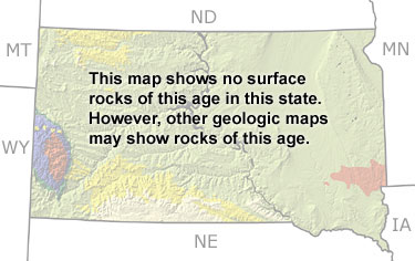
Although this map only indicates the presence of undifferentiated rocks, there are exposures of Carboniferous rocks in the Black Hills region of western South Dakota.