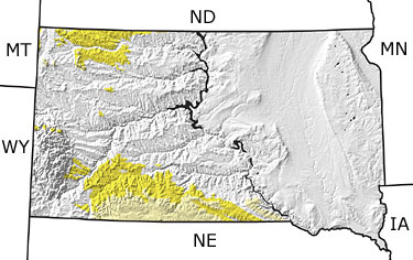
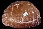
Paleontology and geologyIn South Dakota, the final transgression of the Western Interior Seaway occurred during the Tertiary. This was also a time of major tectonic activity causing both uplift and intrusion in the Black Hills in the western part of the state. This was followed by periods of erosion and deposition. Volcanic activity, probably near Yellowstone Park, contributed large volumes of windblown volcanic ash to the sediments, and climatic conditions fluctuated from warm and humid to dry and cool during this time interval. Numerous grazing mammals inhabited the grasslands that expanded across the state. The White River Badlands, located in the southwestern part of the state, is well known for its diverse fauna, including well-preserved fossils of mammals and tortoises. |