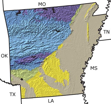
Paleontology and geologyThe Precambrian: There are no Precambrian rocks exposed at the surface in Arkansas. However, evidence from subsurface rocks tells us that there were active volcanoes in Arkansas during this time.
The Paleozoic: A sea inundated the state until the Late Carboniferous. As a result, the Paleozoic sedimentary rocks in northern, central, and western Arkansas were all deposited in a variety of marine environments. With a change in the sea level, newly exposed land in the northern part of the state was eroded by river systems carrying sediments to the sea that still covered the south. By the Permian, the state was completely above sea level, and any Permian rocks that may have formed were removed by erosion.
The Mesozoic: There are no Triassic or Jurassic rocks exposed at the surface in Arkansas; however, they are present in the subsurface. These rocks indicate that the northern and central sections of the state were above sea level, but by the Jurassic, shallow seas flooded the southern area once again. Early Jurassic sediments include common salt deposits resulting from evaporation of the marine waters. Shallow marine deposition continued throughout the Cretaceous in southern and northeastern Arkansas. These deposits contain abundant fossils, including those of oysters, echinoids (sea biscuits), clams, snails, shark teeth, and occasionally fossils of large reptiles.
The Cenozoic: Though most of the southern and eastern parts of Arkansas were covered with shallow seas at the start of the Cenozoic, these seas were not as extensive as they were during the Mesozoic. There are shark teeth and oysters in these Early Tertiary sediments. Sea level fluctuated, but in general receded, so that by the Middle and Late Tertiary, the shoreline was south of Arkansas, and rivers and swamps covered most of the southern part of the state. During the Quaternary, the climate cooled due to the glaciations in the north. Large mammals, such as giant ground sloths, mastodons, and mammoths, roamed the forests and grasslands that covered most of the state. |