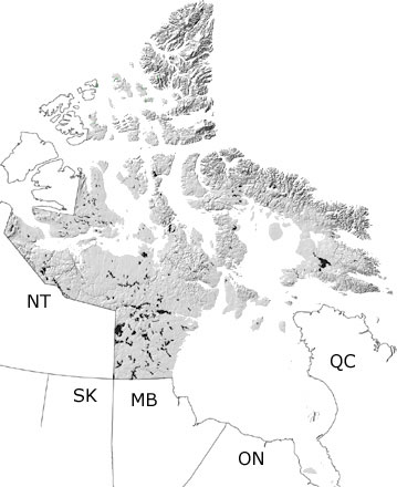
Paleontology and geologyMost of Nunavut was above sea level during the Jurassic. Fossils of cones and leaves, petrified wood and coal deposits suggest that the land was covered in forests of conifers and other plants. There were also lakes and rivers as evidenced by fossils of freshwater bivalves and gastropods. Sediments eroding off the land were deposited in deltas and beaches bordering a basin that covered the northern Arctic islands. Bivalves and ammonites lived in these marine waters, along with various other invertebrates that left their traces in the sand. Fossils of some of these animals and plants can be found in the few exposures of sandstone, siltstone, shale, and coal in the northernmost islands. Additional exposures may be included in the undifferentiated Mesozoic rocks on this map and may appear on other more detailed maps. |